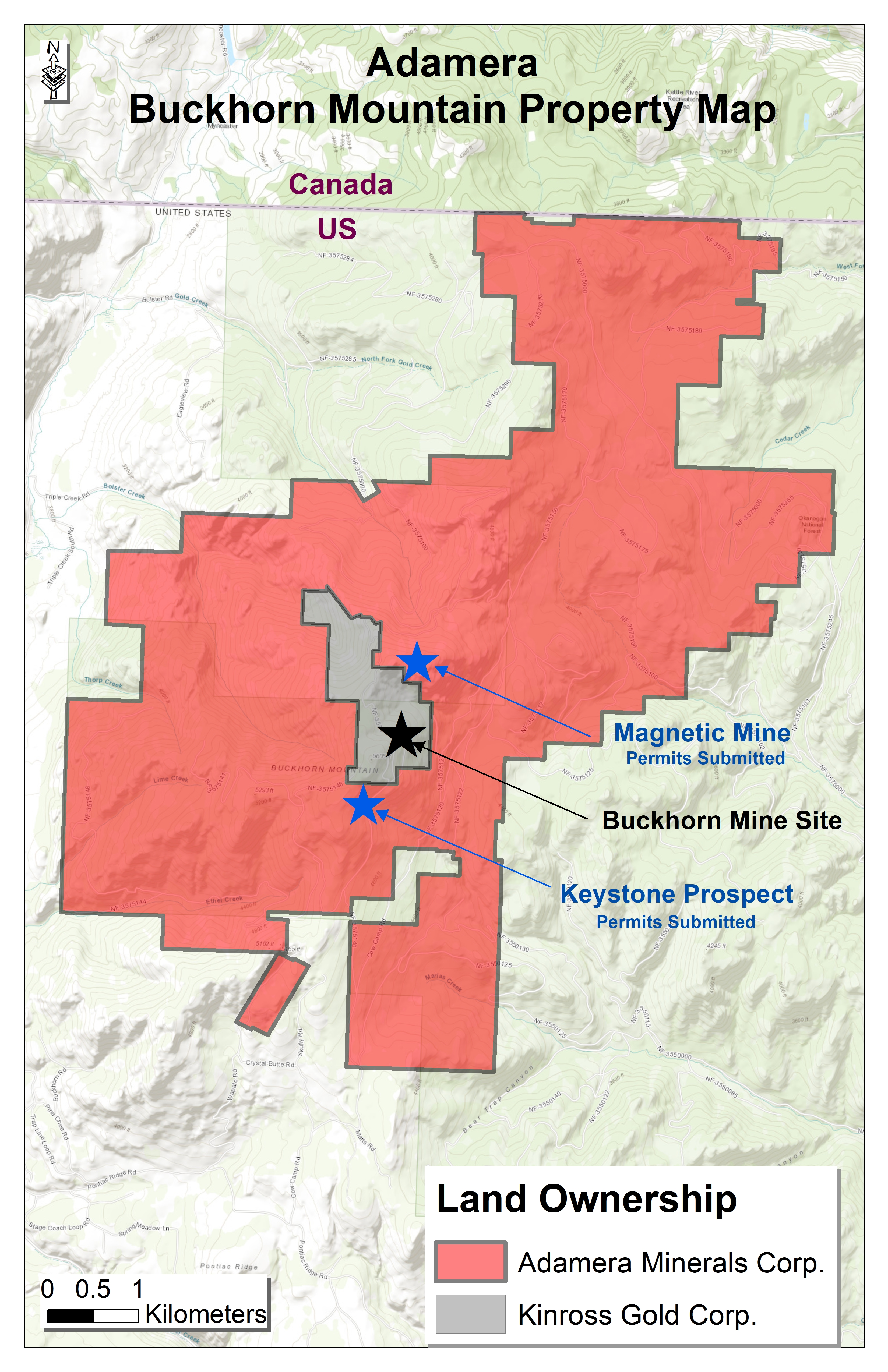
The Buckhorn 2.0 project is 100% owned by Adamera. The project area located in Northeast Washington state covers 9100 acres (36 square km) and extends more then 10 km to the Canadian-USA border, along the western margin of the Torada Graben. Buckhorn 2.0 surrounds the Crown/Kinross patented claims on which the past producing Buckhorn Mine is situated.
The Buckhorn Mine was discovered by Crown Resources Corp in 1988. Approximately 1.3 million ounces of gold at an average grade of about 12 g/t gold was produced from Buckhorn between 2008 and 2017 by Kinross Gold Corp who merged with Crown Resources Corp in 2003.
Adamera's strategy is to aquire land around past producing mines. This area is highly prospective and underexplored due to past companies focused heavily on production. The area has seen very little drilling outside of the deposit.
In mid June 2020 the company began prospecting and geological mapping on the new Buckhorn 2.0 claims. This work identified several prospects including the Magnetic Mine for follow up exploration. Late in 2020, historic drill data from within the Buckhorn 2.0 claim block highlighted a drill intercept with 9 g/t gold over 7.5 metres. According to Adamera’s 2020 geological mapping, the drill intercept is located 1.5 kilometres south of Kinross’ Buckhorn Mine and within the same geological block. Adamera has prepared two separate Plan of Operations on the claim block for anticipated drilling in 2021.
For some time Adamera has been collating information on the Buckhorn mine area to ascertain how much exploration had been conducted outside of the immediate mine area. Based on historical information it appears that Kinross had developed more than 100 targets on the claim block that were not drill tested. Furthermore, they had applied for permits to drill 950 holes from 675 drill pads and construct 120 kms of road to access the drill pads. The size and complexity of process stalled timely progress and the company subsequently dropped the bulk of the original land package to focus entirely on the mine site. The regional potential was determined by Adamera to be highly prospective and largely untested by drilling.
In September of 2021 Adamera completed a data aquisition agreement with a subsidary of Kinross Gold Corp.
The Buckhorn data package is comprehensive. It includes multiple airborne geophysical surveys, a large number of soil and surface rock sample analysis, geological maps, ground geophysical surveys and drill hole results. It is known that multiple drill targets were developed by Kinross using this data, the majority were not drilled.
Adamera deployed geologists and geophysicists to compile and interpret the various datasets to develop targets for drilling. Over 40 targets have been developed and the permitting process will begin on the top selected targets.
In exchange for this data, Adamera reserves a 2% royalty for Kinross on claims held on federal lands and a 0.5% royalty on State lease land. Adamera may purchase half the royalty for $2,000,000.
2022 - Adamera begins drilling ton the Buckhorn 2.0 project
To date in 2022 the Company has drilled 3 targets and a forth is currently being drilled. Sulfide zones were intersected in three separate targets. The three targets are located within 1500 metres of the former Buckhorn Gold Mine. It is well established that gold at the Buckhorn Mine is associated with sulfides.
Below is a brief summary of 3 holes - Assays are pending.
The forth hole is currently being drilled, the VTEM 7 target is described below.
Drill hole BM22-01 tested a coincident magnetic, VTEM, self-potential and VLF-EM anomaly. Several anomalous soil samples with gold values ranging from 300 to 7000 ppb gold were recovered near the drill collar.
Intersected: From 92m to 161.5m - 69.5m of sulfide bearing rock
Drill hole BM22-03 tested a coincident magnetic self-potential anomaly that extends 65 meters to the east and 350 metres to the west to an untested target called VTEM-13. A rock sample collected from outcrop near the drill collar yielded 12.1 g/t gold.
Intersected: From 175.11m to 215.8m – 40.69 m of sulfides with magnetite
Drill hole BM22-02 is currently being drilled. It is testing a strongly magnetic VTEM conductor that was modelled to be 250 metres long by 40 metres wide, extending to a depth of 250 metres. A historic drill hole that appears to have intersected this anomaly approximately 100 metres to the east yielded 5.2 g/t gold over 6.1 metres.
Intersected: From 0 to 13.87m – 13.87m of skarn with sulfides
13.87m to 42.5m – 28.63m of magnetite with sulfides
42.5m to 48.4m – 5.9m of skarn with sulfides
108.8m to 111.4m – 2.6m of skarn with sulfides
111.4m to +152m – Drilling in progress - 41m of skarn with magnetite and sulfides
(still drilling in zone).
VTEM 7- This target is currently being drilled (October 27, 2022) located 2 kilometres from the past poducing Buckhorn Mine.
VTEM7 is primarily a geophysical target, characterised as a VTEM* electromagnetic (EM) conductor with coincident magnetic, VLF-EM and self-potential (SP) anomalies. Significantly it is supported by gold geochemistry.
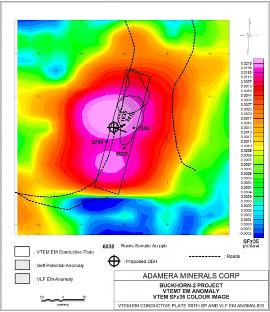
The current drill hole is planned to pass through the center of the VTEM EM plate. A second hole may be required to test the northern extent of the target.
The Buckhorn Mine, a gold-rich skarn with magnetite and sulfides, produced 1.3 million ounces of gold at a grade of 13 g/t. The Buckhorn property is located 80 kilometres by existing road to the Kinross’ Kettle River Mill which is currently on care and maintenence.
Drilling is planned to continue at Buckhorn while favourable weather conditions persist.