Adamera Receives Final Airborne Data for Cooke Mountain Project
Related Document
Vancouver, British Columbia, February 14, 2017 - Adamera Minerals Corp. (TSX-V: ADZ) announces it has received final data from the helicopter borne VTEM and magnetic survey completed over its Cooke Mountain project in Washington State.
Adamera is currently isolating 8-10 tier one targets in preparation for drilling in the Spring. Over the coming weeks, geophysical, geological and soil geochemical data will be compiled over the selected targets. Specific target descriptions within the project area will be released as they are developed.
Upon completing the modeling of tier one targets, the focus will shift to interpreting and modeling the many more subtle anomalies in the data set to develop a roster of tier two targets.
Mark Kolebaba, President and CEO of Adamera commented, "the Cooke Mountain region has never had this type of survey flown over it previously. It is particularly encouraging that we are developing targets within 1.5 km of the Kinross mill, and that several tier one targets have geophysical signatures that closely resemble the responses over recently mined high grade gold deposits in the area. That correlation is what excites me."
The survey was flown over two areas identified by the Company as important mineralized trends. Along these trends, gold deposits occur on specific horizons in association with zones of massive and veinlet sulphides.
Past producing deposits in the survey area that produced +1 million ounces of gold collectively include the Lamefoot, Overlook, Key West, Key East and Belcher mines. They are noted and named on the map below, along with several tier one targets. In addition to VTEM and magnetic anomalies, the Company is also further reviewing airborne AMT anomalies that were identified in 2016.
Drilling can generally be conducted year-round in this part of Washington State, though there is an unusually heavy snow pack this year. Drill permits are being applied for that will cover tier one targets with the tier two targets to be added once they are similarly compiled and ranked.
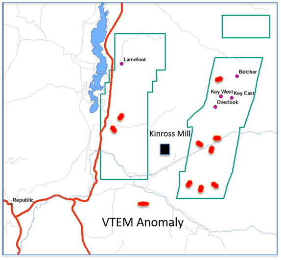
Geophysical surveying was conducted over specific areas within the green polygons. Lamefoot, Belcher, Overlook, Key East and Key West are past producing mines in the area. Red markers represent Tier One VTEM anomalies.
Martin St. Pierre P.Geoph, a Qualified Person as defined by National Instrument 43-101 is interpreting the geophysical data from Geotech Ltd. The final processed data appears well levelled and of good quality interpretation is underway.
About Adamera:
Adamera Minerals Corp. is exploring for high-grade gold deposits within hauling distance of the operating Kettle River Mill in Northeastern Washington State. The Company's strategy is to fast-track the discovery to production process by exploring close to an existing mill in need of ore. Adamera is the dominant exploration company in the area.
On behalf of the Board of Directors,
Mark Kolebaba
President & CEO
For additional information please contact:
Tel: (604) 689-2010
Fax: (604) 484-7143
Email: info@Adamera.com
Website: www.Adamera.com
The TSX Venture Exchange has not reviewed and does not accept responsibility for the adequacy or accuracy of this release. Statements in this press release, other than purely historical information, including statements relating to the Company's future plans and objectives or expected results, may include forward-looking statements. Forward-looking statements are based on numerous assumptions and are subject to all of the risks and uncertainties inherent in resource exploration and development. As a result, actual results may vary materially from those described in the forward-looking statements.